
Leros Construction Modern Tools: The Clash of Methods
Why local renderings lie to you, and how drone photogrammetry, precision 3D modeling, and Artificial Intelligence can save your island project tens of thousands of euros in cost overruns.
Building a house on a Greek island like Leros, Patmos, or Lipsi has nothing to do with a standard real estate project on the mainland. Here, the topography is brutal. The bedrock lies just centimeters below the earth. The Meltemi, this powerful northern wind, can blow at over 80 km/h in the middle of August, turning a poorly oriented terrace into an uninhabitable zone. And above all, the urban planning regulations of the Poleodomia are of Byzantine complexity, dictating volumes, heights, and landscape integration down to the centimeter.
Yet, faced with these extreme constraints, the local standard remains frozen in the past. When you entrust the project of a lifetime to a traditional civil engineering office in the Dodecanese, you generally receive a standardized service, blind to the micro-local realities of your plot. At the heart of this illusion lies what they proudly call the “photorealistic rendering”.
The Dangerous Illusion of Retrograde Practices and Tools
The local civil engineer’s method almost always follows the same pattern. After a basic topographic survey (often just a few GPS points taken in a hurry), your future house is modeled in generic architectural software. The result presented to you is a smooth, aesthetic image, bathed in artificial golden light. On paper, it’s the house of your dreams.
But look closer. This rendering has a major flaw, a hidden defect that will cost you a fortune once the excavators are on the ground: the house is floating in mid-air or resting on an idealized, perfectly flat terrain.
These retrograde renderings deliberately ignore the complex altimetry of the terrain. At Aghios Konstantinos, as on most of the slopes of Leros, the slope is a fundamental factor. An engineer’s plan that draws a vast, level terrace without integrating the slope of the rock fails to mention that hundreds of cubic meters of hard rock will need to be excavated, and above all, three-meter-high reinforced concrete retaining walls will have to be built.
These retaining walls never appear on their pretty 3D renderings. Yet, they require heavy steel reinforcement, massive volumes of C25/30 concrete, and complex drainage systems. Overnight, your structural budget explodes by 30,000 to 40,000 euros, simply because the initial drawing was disconnected from the topographical reality.
Beyond the budget, it’s the living comfort that is sacrificed. These obsolete tools do not simulate the actual path of the sun throughout the year, nor the aerodynamic impact of the prevailing winds. You end up with overheated glass windows in July and outdoor spaces that are unusable because they are swept by gusts of wind.
Here is what you are usually sold: a vision uprooted from its environment.
For the Heliada project, we refused this approximation. We believe that technology must serve the reality of the construction site, not the other way around. The first step in our methodological breakthrough relies on high-precision drone photogrammetry.
Rather than relying on a two-dimensional topographic survey with a dozen altitude points, we fly over the plot with our state-of-the-art equipment (DJI Air 3S). We capture hundreds, sometimes thousands of high-resolution aerial photographs from different angles, coupled with precise GPS coordinates.
These data are then processed by powerful algorithms that recreate a 3D point cloud of several million polygons. The result? An exact digital replica of your land, accurate to the centimeter. Every rock, every unevenness, every existing tree, every dry stone terrace is digitized. We are no longer dealing with a theoretical blank page, but with a true Digital Twin of the Leros topography.
This absolute mastery of the terrain changes everything. It allows us to design architecture that embraces the slope rather than fighting it. We can calculate the exact volumes of cut and fill with formidable precision. There are no more surprises during the excavation phase. Subcontractors’ quotes for the structural work become contractual and firm, as they are based on indisputable measurements derived from our drone survey.
Furthermore, photogrammetry gives us a decisive weapon for the approval of the building permit by the Poleodomia. We can mathematically prove that our project respects the natural profiles of the terrain, a sine qua non condition in the protected and regulated areas of the Dodecanese.
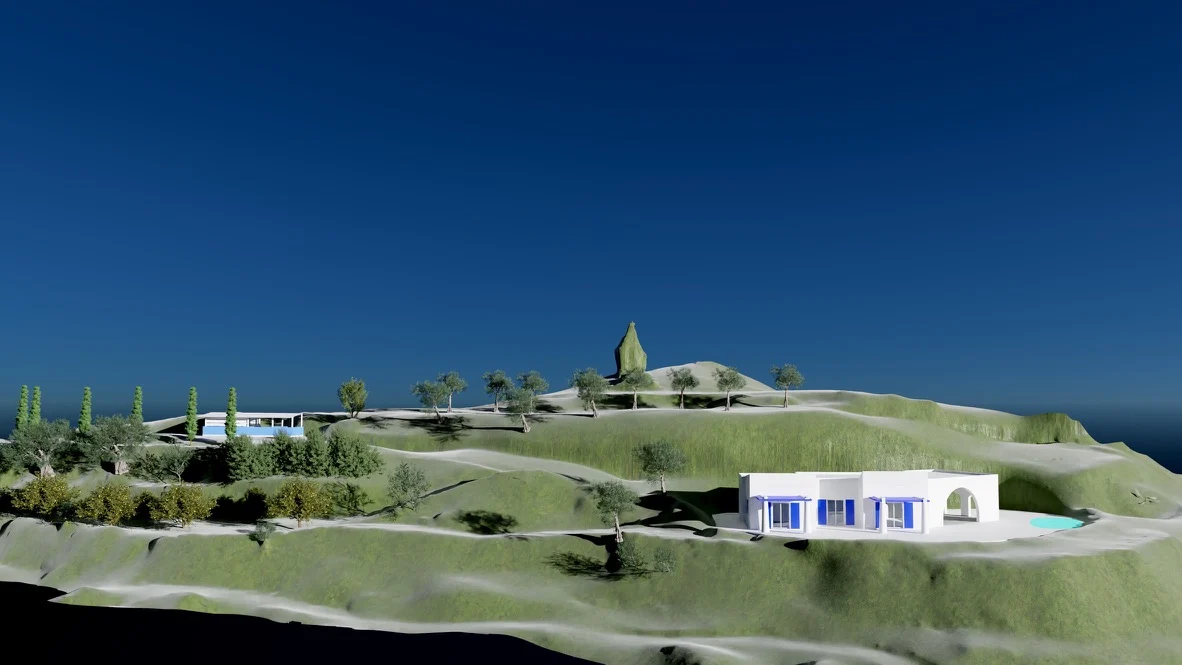
” This is not an image, it is a 3D rendering made with Blender, the lighting is exact with the real sunlight. Coupled with the drone photogrammetry of the terrain: it is a unique, rare but fundamental basis for the success of your project! It allowed for provisional earthworks, pathways on the land, the photovoltaic platform, massive savings during the actual excavation and above all, placing the house ideally! Three professionals came to the plot and no one had envisioned the house in this location. No one agreed, by the way, and we’ll spare you the nonsense we heard!!”
Advanced 3D Modeling: Mastering the Elements
Once the Digital Twin of the terrain is generated, we integrate the 3D modeling of the house into it. This is where the Heliada approach truly makes sense. Unlike the engineer’s photorealistic rendering which only serves as a commercial brochure, our 3D model is an environmental engineering laboratory.
Since the house is anchored in its real topography, we can run dynamic simulations crucial for island autonomy and comfort:
1. Shade and Wind (The Meltemi Challenge):
We study the orientation of the building to the exact degree. By judiciously orienting the L or U-shaped volumes, we use the structure of the house itself as a shield against the prevailing north-western winds. Our 3D models allow us to simulate wind corridors and ensure that your living terraces and pools or ponds remain true havens of peace, even when the wind blows a gale over the bay of Germanos.
2. Photovoltaic Sizing: An autonomous house depends on its solar yield. Our 3D model calculates the cast shadows from the surrounding relief, the hills of Aghios Konstantinos, and even the roof parapets on our future solar panels. We know exactly how many kilowatt-hours the roof will be able to produce in the middle of winter, allowing us to size the LiFePO4 battery bank and hybrid inverters as accurately as possible.
3. Technical Anticipation: The model integrates the real thickness of the walls, thermal insulation, dual water network systems, and conduits for local home automation. We are not drawing a picture, we are building the house digitally before pouring the first cubic meter of C25/30 concrete.
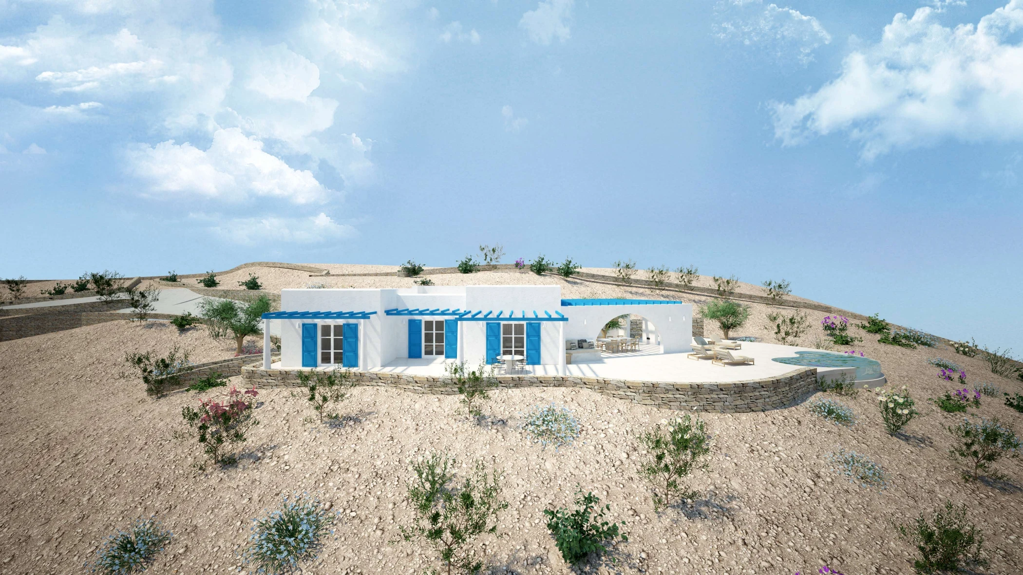
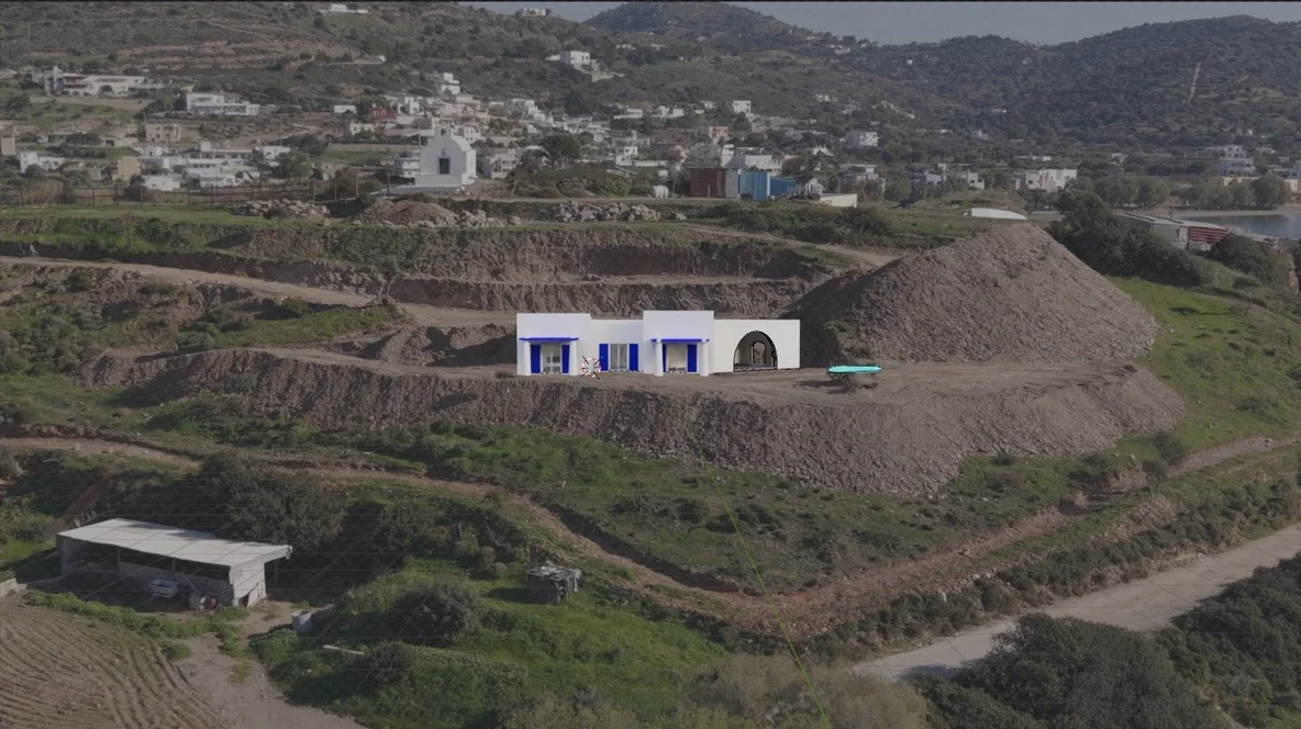
” The professionals’ photorealistic rendering above: 3 weeks for such a result. It’s not very nice, not very realistic, but above all it’s completely and utterly wrong “
Generative AI: Layout Simulations and Exterior Styles
The structural work and geometric layout are only part of the equation. The true character of a residence in the Dodecanese lies in its finishes, its exterior landscaping, and its ability to blend into the Mediterranean landscape. This is where our methods once again diverge radically from local practices.
Where a design office will charge you for every texture modification of a wall or pergola on their computationally heavy renderings, we use the power of generative Artificial Intelligence (Gemini, local LLM workflows, and specialized image generators) to create design iterations at the speed of thought.
On the Heliada site, we are currently facing the challenge of landscaping the exteriors around the rehabilitated annex (the double garage and workshop). How do we harmoniously link the old local stones, the traditional lime plasters, the rough flagstone pathways, and the shading structures?
Starting from the geometrically exact 3D bases of our plot, we provide the context to the AIs to generate dozens of style variations. We instantly test the visual impact of a modern bioclimatic pergola against that of a traditional driftwood trellis covered in bougainvillea. We compare the renderings of a dry stone wall repointed with a scraped render typical of Leros’ local architecture.
These AI simulations are not just visual “gimmicks”. They are strategic decision-making tools. They allow us to validate aesthetic choices before ordering expensive materials from Piraeus or Athens. They offer total flexibility to explore complex landscape concepts, plan the integration of drought-resistant endemic plants, and design parking areas without altering the approach to the bay.
Browse through some of our Artificial Intelligence-generated iterations for the garage exteriors below, proving that it is possible to marry the authenticity of the island with an ultra-modern design methodology.
CHRONICLE OF A FORETOLD FAILURE: OUR GARAGE …AND HOW WE AVOIDED IT
Oh, this garage has come a long way!! We were lucky enough to recover the walls of a very old stable on the land! The civil engineer’s first comments: it all has to be razed, and he gave us this magnificent proposal.
Of course this was out of the question, so he suggested cutting the walls down in height and filling the inside with earth…. Yes, yes, you read that correctly, filling it with earth. He was convinced it would be an obstacle for the permit, which was never the case. So, we provided our 3D model made with Blender and it was transcribed like this….
Our request
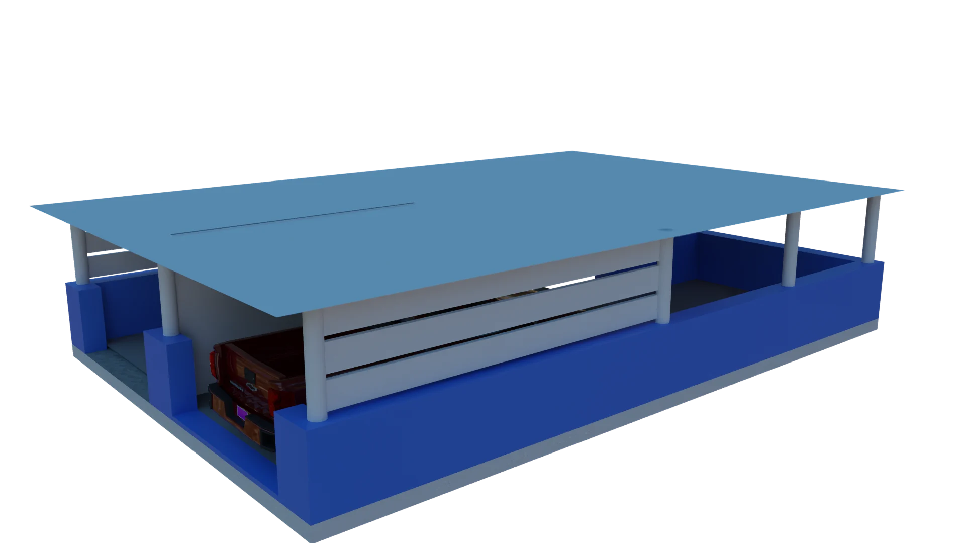
The professional proposal
Complete, of course, with concrete columns featuring a nice thick anti-seismic metal reinforcement to hold up super-resistant PVC shutters for a seaside house. Nobody does that, but that’s what we were served… Of course, the columns were changed in the official building permit documents to make conical ones that subsequently prevented any lateral protections. Believe me, it hurts to have to pay fees to such incompetents who think they know everything!!!
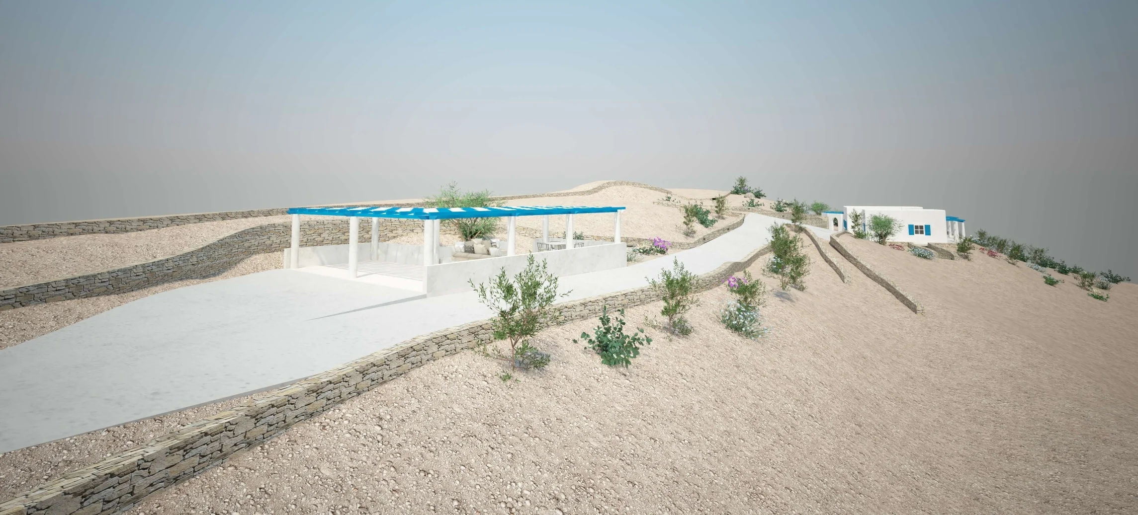
So we followed our own idea, the modeling one, and we used simulations with Nano-Banana on Google Omni Flow on drone images…
THE CURRENT SITUATION

THE AI SIMULATION OF FINISHES
AI SIMULATIONS FOR EXTERIOR LAYOUT
(including Gemini’s hallucinations, sometimes an error gives an idea)
Choosing Leros-island.com means adopting the best for your home
Choose HELIADA.LIVE for your house in Leros
The Heliada site is not just a house; it is proof by example. By replacing empirical methods and misleading renderings with data (photogrammetry), bioclimatic engineering (3D modeling), and visual innovation (AI), we regain total control over costs, deadlines, and architectural quality.
Don’t leave your island project to the chance of engineers’ sketches disconnected from the terrain.